
Urban development
Road surface inspection
MMS(Mobile Measurement System)is a system for obtaining highly accurate geospatial data from a moving vehicle.
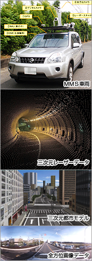
1) The MMS is comprised of the following advanced equipment:
- Global positioning system (GPS)
- Internal measurement unit (IMU)
- Digital measurable images
- Digital camera
- Laser scanner
- Omnidirectional video
2) The MMS scans its entire surroundings as the vehicle moves, obtaining the following geospatial information:
- Positional data
- Stereo image data
- Three-dimensional data
- Omnidirectional data
- The system acquires highly precise three-dimensional data as the vehicle moves. When the vehicle momentarily losses GPS reception such as when it passes through a tunnel, the IMU corrects the positional data.
- Because the MMS can take measurements at the legal speed limit there is no need for traffic restrictions or cause for traffic jams.
- Topography and buildings are measured and digitized using 3D laser data and stereo imagery data. As this data meets standards for public surveying under Japanese law, it is possible to use this data to make road directory maps and base maps.
- The omnidirectional data allows for the condition of the road and both sides of the road to be confirmed.
- The three-dimensional laser enables the measurement of tunnels and the acquisition of 3D road data. Moreover, when this is combined with aerial laser data a 3D urban model can be developed.
![]()
Vehicle-Based Survey (Mobile Mapping)
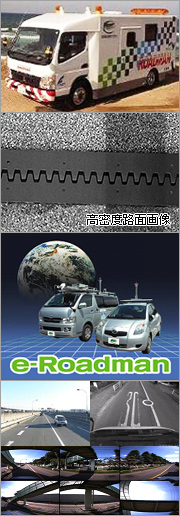
Social capital in Japan is shifting from an era of building (construction) to an era of using (maintaining/managing) infrastructures while improving their quality. It is becoming essential to minimize the lifecycle cost necessary for maintaining/managing the roads that are so essential to our lives, as well as the public spaces created by these roads, while improving the service level.
Mobile mapping is an excellent technology for efficiently and effectively collecting the information necessary for managing road assets. Kokusai Kogyo’s mobile mapping technology can provide asset management information that suits individual needs from collected roadside images and the Airborne Laser Scanner.
- From the collected images, we evaluate the condition of a road surface (determined based on the cracking ratio). Based on the assessment result, the user can create a prevention/maintenance plan and develop a maintenance/repair budget.
- From the collected images, we can check and evaluate facilities related to roads. The information is useful for checking the content of road signs, the state of deterioration of guardrails, and the posting of illegal advertisements.
- The collected images and evaluation results can be easily viewed on a personal computer using a viewer linked to a Google Maps.
- Efficiently builds road information base data.
- Road scenery evaluation results can support future qualitative improvements to social capital.
- Helps build a safe and sound society by evaluating the health of the roads.
![]()