
Urban development
GIS to manage public infrastructure
Building and Installing Portal for Sharing River and Road Data
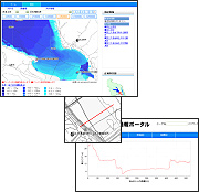
Data sharing based on geospatial information is extremely effective in efficiently supporting operations for maintaining and managing rivers and roads, which make up an important part of the national infrastructure.
Based on analysis of business models and utilizing a system-to-system coordination technology, we help our customers build and install data systems that serve as the portal for sharing data that otherwise would be scattered throughout their business offices.
- We can build portal systems that adopt a search interface for achieving effective data sharing.
- Our portal system utilizes geospatial information, which becomes the basis for road infrastructure data and river infrastructure maps.
- We can link and manage maps attached to road registers with data in other facility management registers.
- We can build a system that complies with the standard interface for linking data, such as the riverine GIS and the river application standard interface.
![]()
Erosion Prevention Data Management
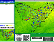
According to statistics complied by the Ministry of Land Infrastructure, Transport and Tourism, more than 520,000 locations throughout Japan are prone to the risk of sand and stone avalanches. In 2001, with the goal of promoting proper land use and establishing a warning and evacuation system, the Sediment-Related Disaster Prevention Act was enacted, requiring clear identification of disaster-prone areas.
To implement these preventive measures, managing disaster prevention data becomes even more important. By collecting and managing the massive amount of data involved and promoting data sharing among various bureaus and departments, Kokusai Kogyo is supporting effective administrative actions for erosion prevention.
- Our advanced spatial information technologies support effective administrative actions for erosion prevention.
- We build highly objective spatial data that is easy to understand.
- We standardize topographic analysis methods and operation systems.
- We can help develop a sediment-related disaster prevention network that will support public, mutual, and self-assistance.