
Climate change countermeasures
Flood simulation modelling
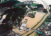
Sudden and extremely intense rain and thunderstorms are becoming more common due to global warming. This in course is leading to heightened risk of flooding near rivers as a result of levees being compromised and in urban areas as a result of drains and sewers being unable to cope with a sudden deluge.
Computer modelled flood simulations can be made by developing a database of precise elevation and river flow capacity data. Then by estimating rainfall, such simulations can be used to facilitate development of evacuation and flood risk reduction measures.
- Detailed topographic models, made by aerial laser survey, are used to conduct accurate simulations that include the status of levees and river banks.
- A highly accurate and realistic simulation can be produced using a “dispersed runoff calculation model” that can account for land use, soil type and geology.
- Various visual aids to easily portray flood risk to reduce disaster loss can be made based on the results of the simulation such as hazard maps, estimated inundation maps and 3D computer simulations.