
Climate change countermeasures
Comprehensive disaster prevention information system
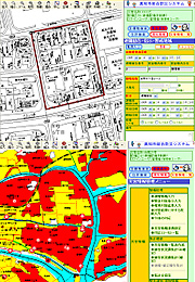
The disaster prevention information system is a subsystem that can be used as an add-on application to the integrated SonicWeb GIS.
This system consists of individual subsystems designed for the prevention, emergency response, and restoration phases, including (1) Map data system, (2) Disaster data collection and communication system, (3) Evacuation support and data systems that predict loved ones’ safety, and (4) Disaster situation communication support system.
This system was developed with the objective of reducing damage during disasters, by helping those in charge to make appropriate decisions and accelerating the implementation of relief measures. It also supports disaster prevention operations.
-
[Prevention phase]
Regional characteristics, such as topography, geology, subsoil depth, and disaster risk, as well as disaster history, disaster prevention facilities, and local disaster prevention organizations are stored in a database, from where they can be accessed and utilized for developing various types of disaster prevention plans.
-
[Emergency response phase]
Even during the confusion that follows a disaster, we systematically collect data from residents and various locations and manage its use, in order to accurately grasp the overall picture of the disaster. By establishing an initial response structure that corresponds to the size of the disaster and the extent of its influence, we help ensure rapid and efficient emergency response operations.
-
[Restoration phase]
Based on the various types of data that have been input, we carry out damage surveys to accurately assess the damage. In addition, we assist in disaster relief operations such as obtaining disaster victim certification and applying for relief under the Disaster Relief Act, to support the rapid creation of a restoration plan.
-
[Easy-to-use user interface]
You can register frequently used menu items in toolbars and check all graphics and attributes in a single window.
-
[Extensive map data retrieval functions]
The system comes with extensive map data retrieval functions, including graphic index search, drawing number search, facility number search, ZIP code search, target object search (allows the user to add or update the target object), and address search (to access city district reference data, housing map data, etc. provided by the Geospatial Information Authority of Japan).