
Geospatial × ICT
Geospatial information database service PAREA
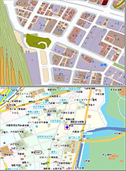
PAREA is Kokusai Kogyo’s geospatial information database. It is an up-to-date information platform, adapted into four series to flexibly meet the various needs of our clients.
- AreaMap Series consists of polygon data of various boundaries such as between each post code area.
-Is an extremely detailed point database of every suburb of Japan down to individual property boundaries. - GeoMap Series consists of road and topography data.
-Is a road map database covering roads, rivers, coastlines, railways, and boundaries between cities, towns, villages, etc., and also contains information for predicting traffic conditions. - Information Series consists of landmark data with attributes.
-Is a database containing locations of every kind of landmark such as hospitals, schools, dentists, post offices throughout Japan, as well as attribute information for every landmark. - StatSeries is a series of statistical data.
-Is a database of the population and number of households in each area of Japan down to the level of postal codes, and also ranks every household according to income level.