
Base technologies
Water Area Survey
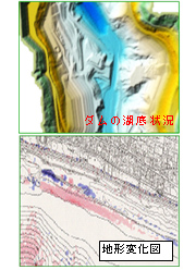
Sea Floor / Lake Floor Terrain Measurement
Underwater topography cannot normally be seen directly, but is essential core data for disaster prevention and environmental purposes, a part of peoples’ daily lives.
Kokusai Kogyo uses underwater measurement technologies such as the acoustic beams used in systems such as narrow multibeam sonar systems to provide accurate terrain data.
- We link RTK-GPS and narrow multibeam sonar systems to measure terrain in 2D, providing terrain data in mesh increments from 0.1m to 5.0m, in accordance with customer needs.
- By measuring sea floor terrain and lake floor terrain over time, beach erosion and sediment quantity changes can be accurately and quantitatively assessed.
- The placement and scattering of structures on the sea floor can be accurately determined.
- Fine mesh terrain data can be used to improve the accuracy of tsunami and storm surge simulations, as well as wave and current analysis and the like.
- This technology is a more advanced version of the technology which received assessment certification by the former Transport Ministry in 1997 under regulations concerning the evaluation of private sector technologies related to commercial ports. (No. 97204)
![]()
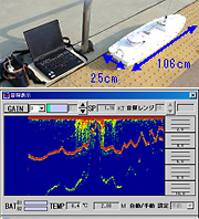
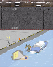
Remote Controlled Boat Depth Measurement
Terrain data for areas through which measurement ships cannot pass, such as extremely shallow reefs, seaweed beds, tidal zones, and river rapids, contain information that significantly affects the accuracy of terrain change analysis, tsunami and storm surge simulations, flood analysis, and the like. Kokusai Kogyo has developed, together with Coden Co., Ltd. remote controlled survey boats, which are used to provide actual measurement data for shallow areas for which measurement has not been previously possible.
- Measurement is performed by using wireless LAN to remotely control, from land, special boats with mounted GPS and 200KHz acoustic sounders. Depth measurement conditions can be constantly monitored from standard PCs.
- Survey lines can be set in advance to enable depth measurement using autonomous navigation.
- Preparation work is simple, making rapid response during times of emergency possible with a minimal number of people.
- An optional CCD camera can be installed, making undersea video filming possible.
- This technology is already registered in the Ministry of Land, Infrastructure, Transport and Tourism’s NETIS new technology utilization system for use in public works, etc.
(Registration number KK-080050-A)
![]()
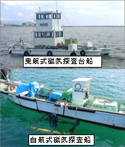
Marine Magnetic Exploration
There are areas of the ocean which still contain sea mines and torpedoes dropped or placed by the US army during World War II in order to seal off sea areas. Kokusai Kogyo uses magnetic detectors to discover dangerous objects such as unexploded ordnance, contributing to the safety and security of commercial port construction, port users, and surrounding communities.
- We can confirm whether or not there are remaining dangerous objects, securing the safety of commercial port construction.
- Precise locations of dangerous objects are determined via GPS positioning information and magnetic record waveforms.
![]()
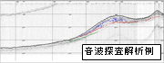
Acoustic Exploration
Acoustic exploration technology was developed in order to perform petroleum resource exploration development surveys.
It is based on the principle of directing low frequency sounds towards the sea floor, and using the reflection speed and reflection intensity of the waves bouncing off underground strata to read seabed layers.
It is now used in investigations of sea floor geology (active faults) and resources, as well as determining in 3D the conditions (soil properties) of the bases of commercial port structures, and the movements of undersea deposits.
Attention is being drawn again to this exploration technology due to the Basic Act on Ocean Policy’s creation of momentum in the securing of national resources in the waters around Japan.
- We assess sub-sea floor geology and provide necessary information in digital form.
- The obtained data can be used in route surveys for pipelines, undersea cables, and the like.
![]()
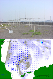
Current and Wave Measurement via Marine Radar
Normally, the assessment of current and wave (wave height, period, and direction) distribution from the shore to several tens of km off-shore has necessitated the installation of multiple current meters and wave gauges within the sea, and long-term measurement (for current, from 15 days to 1 month, and for waves, in order to see seasonal changes, several months). However, cost and installation method limitations restricted the number of observation points, making it extremely difficult to simultaneously assess 2D marine phenomena information over wide areas. For that reason, simulations were performed for areas without data, but it is difficult to reproduce the effects of weather and complex land forms in simulations.
Maritime radar uses high frequency and ultrahigh frequency band electromagnetic waves to perform continuous real-time measurement from land of marine phenomena (current, waves).
Leveraging the marine radar based measurement and analysis technologies it has nurtured over the years, Kokusai Kogyo can propose investigations, install measurement equipment, perform current condition and wave data mapping, and analyze and process the results of that mapping. We also have extensive experience in building systems such as systems for distributing marine radar measurement data over the Internet, or systems for using current data in seaborne garbage distribution forecasting. We use our extensive repertoire of technologies to propose and create systems in response to the needs of our customers.
- Real-time 1 hour incremental measurement of sea surface currents and waves (wave height, period, and direction) is possible for anywhere between several dozen to a maximum of 100 km from shore.
- The number of measurement points and data acquisition positions can be freely set within the radar measurement scope.
- Data acquired via marine radar can be displayed and distributed via the Internet.
- Absolutely no off-shore work (installation, inspection, removal) is needed.
![]()
Underwater Structure Deterioration Diagnosis – "Measuring Within the Water"
Until now, underwater structure deterioration diagnosis work has been done by visual observation by divers. We are developing* equipment using high-resolution, high-speed acoustic video cameras to perform this work efficiently and safely.
* Joint research and development with the Public Works Research Institute Civil Engineering Research Institute for Cold Region and the University of Tokyo Institute of Industrial Science (patent pending)
- Until now, observations of structural deformation have been performed based on sketches by divers, whose accuracy varies based on water conditions such as clouding, as well as individual skill levels. Deterioration diagnosis equipment makes it possible to provide objective deformation diagrams composed of images of entire pier sides.
- Acoustic video cameras can capture structural deformation conditions regardless of the degree of water clouding.
- Use of this equipment is both more efficient and safer than diving.
- Deformation records can be stocked and progress over time checked in order to perform appropriate structure maintenance management.
![]()