
Base technologies
Land Use History Investigation
Land Use History Investigation
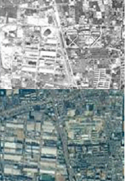
Before a land use is changed, the land use history of the target land and its surrounding area must be investigated in order to determine whether there are factors or potential for factors, such as soil contamination, that may restrict its use. When land is to be surveyed in accordance with the Soil Contamination Countermeasures Act or prefectural ordinances, a land use history investigation is mandated. We carry out land use history investigation by referencing new and old topographic maps, land condition maps, geological maps, certified copies of register, and past residential maps, as well as various survey results produced by government agencies. Furthermore, if necessary, we also interpret past aerial photographs and conduct on-site surveys.
- This is the basic survey necessary for purchasing quality land.
- We check for bad ground and underground obstacles, and determine groundwater conditions.
- We check for factors such as archeological ruins that may restrict construction.
- We check for risk of soil contamination.
- We conduct an investigation to determine the cause of contamination if land is known to be contaminated.
- We check for past disaster records based on ample data.
- We reproduce the actual situation in detail utilizing our rich experience and expertise in interpreting aerial photographs.