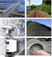
Base technologies
Analyzing Land Contour
- Topographic Contour Analysis (Elsa Map)
- Image Decipherment Investigation (Aerial Photograph Decipherment, Numerical Terrain Data Image Decipherment)
- Ground Surface Characteristics Analysis (Assessment of Landslide Distribution)
- Land Deformation Analysiss (Assessment of Sand Movement Volume and Ground Surface Movements)
- GPS-based displacement monitoring
- Underground Geology Analysis
- Disaster Prone Location Evaluation
- Snow Accumulation Condition Analysis
- Soil Movement Simulation (Sand and Stone Avalanches, Lava Flows, etc.)
- Volcanic Ash Movement Simulation
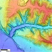
Topographic Contour Analysis (Elsa Map)
Our proprietary Elsa Map (Color-coded Elevation and Slope Angle composite Map), which is a transparent 3D composite map of elevation and slope angle, allows the user to intuitively understand the land contour.
- The Elsa Map is especially useful for intuitively understanding subtle topographic features derived from high-density topographic data, such as laser survey data.
- By adjusting the elevation-indicating hue and slope-indicating brightness, the user can easily change how the subtle topographical features of the desired area will be displayed.
![]()
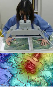
Image Decipherment Investigation (Aerial Photograph Decipherment, Numerical Terrain Data Image Decipherment)
The well-received aerial photography decipherment technologies made possible by Kokusai Kogyo’s experience in fields such as the erosion prevention, disaster prevention, and environmental fields, together with image decipherment using topographical maps making use of recent numerical terrain data, makes it possible to accurately express terrain to a fine degree.
By fusing cutting-edge high resolution terrain data with the analogue technologies we have cultivated over the years, we can provide optimal spatial data for earthquake, volcano eruption, landslide, and other disaster prevention, environmental measures including planting, agriculture, and civil engineering, and development.
- National spatial conditions (especially detailed land forms, geology, and vegetation) can be determined accurately and in detail.
- National spatial changes (trends) over time can be accurately determined.
- Landslide, collapse, sand and stone avalanche, volcano, and other land-forming and change processes can be foreseen.
- Locations dangerous from the perspective of disaster prevention, such as steep slopes, volcanoes, and active faults, can be determined.
![]()
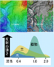
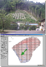
Ground Surface Characteristics Analysis (Assessment of Landslide Distribution)
Kokusai Kogyo’s patent-pending pulse/reflection intensity technology can automatically identify bare land and ruptured ground areas, helping make the utilization of Airborne Laser Scanner data more effective.
- This technology automatically identifies bare land and ruptured ground areas based on proprietary laser survey data processing.
- This technology can identify bare land and ruptured ground areas that are in shadow, which are difficult to identify in aerial photography, with uniform planar accuracy.
- This technology is especially useful for quickly assessing the situation following a large-scale soil erosion disaster.
- Change over the years for multiple time periods can be accurately assessed, enabling the accurate assessment of medium/long-term sand dynamics, and serving of use in appropriate basin sand management.
![]()
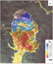
Land Deformation Analysiss (Assessment of Sand Movement Volume and Ground Surface Movements)
Based on a complete understanding of surveying principles, Kokusai Kogyo can suggest an effective and economical laser survey that is uniquely tailored to the customer’s actual application. Furthermore, the expertise we have derived from our experience of handling a rich mix of data allows us to determine the soil erosion volume and ground surface movement from ground surface survey data collected from at least two points of time.
- We quantitatively determine the soil erosion volume and ground surface movement from high-quality ground surface survey data collected from at least two points of time.
- Using a differential analysis, we express changes in the ground surface following an earthquake or torrential rain in easy-to-understand planar representation.
- We assess detailed movements of soil by comparing cross-sectional data before and after an event.
![]()
GPS-based displacement monitoring
This is a maintenance and management support service that uses a GPS-based automatic measurement system to measure dislocations of the subsoil or building structures in 3D, in mm units, on a real-time basis, in which full-time engineers monitor the measured dislocations 24 hours a day, 365 days a year. Essential disaster prevention information, such as this measurement data, is provided via the Internet for a fixed monthly fee.
- We use the latest GPS-based automatic measurement system to measure dislocations of the subsoil or building structures in 3D, in mm units, on a real-time basis.
- Our full-time engineers monitor the measured dislocations 24 hours a day, 365 days a year and notify (telephone or e-mail) the customer when any abnormality is detected.
- We offer analysis using a trend model results in highly precise (approximately 2 mm) dislocation measurements.
- Customers can use the Internet (or mobile phone) to check the latest measurement results.
- In addition to the measured dislocations, we also deliver climate information such as rainfall and weather forecasts.
- The service is available for a low, fixed monthly fee (which includes both the GPS unit and the communication expenses).
![]()
Underground Geology Analysis
Recently, in efforts to develop social capital, society’s focus has drastically shifted from quantity to quality. Geological surveying now requires technologies from a wide range of fields, in addition to those used for interpreting topography and surveying geological characteristics. In addition to the services it has always offered, Kokusai Kogyo is now also offering the latest, most efficient and comprehensive geological consulting (developing planar information from points and line data by utilizing a spatial information technologies), using new survey, measurement, and analysis technologies.
In each type of survey, we utilize the latest spatial information technologies, including the use of LP data, to produce results that are easier to understand and more credible than ever before in various fields including disaster consultancy and the environment. Our survey methods include the use of a terrestrial laser scanner for quickly surveying topography, a Hi-Vision system for visualizing shape changes in tunnels, etc., and a thermal image analysis system for quantifying the shape changes of structures such as bridges and the faces of slopes. These systems allow us to produce highly accurate quantitative evaluation results solidly backed by data, and in this way to contribute to the maintenance/management field.
Furthermore, we provide a wide range of services by utilizing this base data and by building GISs that fully utilize the latest digital technology useful for efficient management and information disclosure. We will continue to offer comprehensive consultancy services in the fields of subsoil, groundwater, subsoil environment, disaster prevention, rivers, and erosion control, with attention given to efficiency, safety, and co-existence with the environment.
- Applying the latest terrain analysis technology to slope disaster prevention, we suggest efficient and effective surveys and countermeasures.
- We combine our solid record in topographical/geological analysis with the latest ground analysis technology to conduct civil engineering and geological surveys, utilizing the results to develop highly cost-effective designs.
- We also offer services in the field of environmental geology, including survey of the problem of naturally occurring heavy metal pollution, as well as vegetation analysis using spatial technology.
- In addition to conventional soil surveys and safety investigations, we can suggest measures for river levee safety by utilizing our spatial information technology.
- Based on our ample survey records and groundwater analysis technology, we perform groundwater impact assessment related to road and river construction projects.
- Through full utilization of the latest survey technologies, we are able to help our customers maintain/manage structures and various facilities, with a focus on lifecycle cost reduction and useful life extension.
![]()
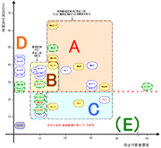
Disaster Prone Location Evaluation
As area specification progresses in accordance with the Sediment-Related Disaster Prevention Act, it will become necessary to promote specific measures, such as hard and soft countermeasures, in individual areas and regions. Disaster prone location evaluation is important to implementing measures effectively and efficiently.
Kokusai Kogyo utilizes basic survey results and other materials, using collapse and sand and stone avalanche occurrence risk degrees, conservation target importance, and measure implementation difficulty as indices when performing disaster prone location evaluation. The evaluation results can be used to establish highly accountable operating plans.
- A variety of indices are used to consider items such as "disaster occurrence risk," "conservation target importance," and "ease of implementation."
- Each index is cross-evaluated, and hazard location type evaluation is performed.
- By categorizing locations by type, highly accountable operating plans can be established. In particular, approaches to locations requiring emergency handling can be evaluated on a case-by-case basis.
![]()
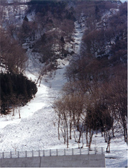
Snow Accumulation Condition Analysis
Over half of our nation’s land consists of snowy, cold regions, and is faced with a variety of types of snow damage every winter, including avalanches, blizzards, road freezing, and snow melt runoff. On the other hand, snow is also a bounty for us, from a water resource and thermal energy perspective. For us, living as we do here in Japan, understanding snow is extremely important.
Kokusai Kogyo is fusing its over 30 years of snow and ice investigation know-how with spatial data in order to solve a wide array of problems related to snow.
- Snow accumulation surveys and wide-area, high-accuracy spatial data obtained from airplanes are used to create avalanche hazard maps.
- We use airplanes to gain a wide-area, highly accurate understanding of snow buildup depth distribution, creating snow buildup depth models and snow melt runoff models.
- Numerical simulations are used to perform blizzard and avalanche analysis, with the results used to support effective countermeasures.
- Effective road freezing prevention measures support more highly advanced winter road surface management.
![]()
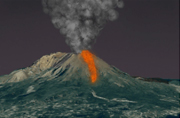
Soil Movement Simulation (Sand and Stone Avalanches, Lava Flows, etc.)
As the saying goes, disasters always strike when you are least expecting them. Ordinary disaster prevention maps alone may not be sufficient to help people visualize the risk of disaster in some cases. Utilizing the spatial information collection technologies and modeling expertise it has nurtured over many years, Kokusai Kogyo runs numerical simulations of soil movements and volcanic eruptions, and provides the results in the form of computer graphics and animations that can be easily understood by the general public
- In order to accurately portray potential disasters, we run numerical simulations based on past disaster records, on-site surveys utilizing spatial information, and analysis results.
- We process our data into computer graphics and animations that can be easily understood by the general public and help them visualize disasters.
![]()
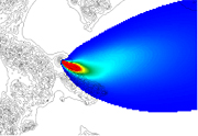
Volcanic Ash Movement Simulation
Kokusai Kogyo has long contributed to the advancement of measures to prevent volcano-caused disasters in Japan. We run numerical simulations that match the characteristics of each volcano and provide the data necessary for disaster and risk forecasts.
- By assessing the characteristics of each volcano, we make forecasts that address eruption size and mode.
- We analyze the climatic conditions of the target area to make our forecasts more realistic.
- We provide our data in a format that helps users easily visualize volcanic phenomena so that it can be utilized as the base data for volcano disaster prevention maps and disaster prevention plans.
- Volcanic ash fallout likelihood forecast maps can also be created, to be used in damage prediction and risk assessment.