
Geospatial information services
Landscape planning
Societal changes have resulted in changes to the approach to social capital, and with them has come a need for more positive road scenery and road environments. Kokusai Kogyo uses cutting-edge digital technologies to provide high quality roads in line with society’s needs.
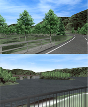
In addition to road design using 3D data, Kokusai Kogyo also provides CG simulations and photo montages, making it easy to visualize the road scenery created by road structures, and the view from street level.
- High-resolution digital orthophotographs, a type of aerial photography, multi-direction aerial oblique imagery (Pictometry), and other Kokusai Kogyo library elements are used when considering road scenery, and CG images and photo montages are created to present scenery and road plan explanatory materials in an easy to understand format.
- Airborne laser scanning, a land survey technology which radially emits a laser from an airplane toward the ground to perform measurements, is used to acquire data, which is further processed in the creation of digital elevation models (DEM) and 3D city models. These DEM are used in 3D road design.
- VR models are created for scenery forecasting. VR stands for Virtual Reality, and these VR models show current 3D landforms and road plan proposals on a display. The perspective displayed can be changed freely via input peripherals such as computer mice or video game controllers.