
Geospatial × ICT
Fixed property taxation support system
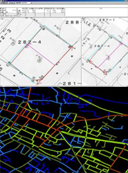
Our fixed property taxation support system enables you to use a personal computer to systematically use and manage the various types of map data related to fixed properties, created through taxable property identification and land value assessment operations. Additionally, it will assist you with the day-to-day tasks involved in fixed property taxation operations. While reducing the daily workload and improving efficiency, our system also helps improve a wide range of services provided to local residents by electronic local government.
Introducing our system offers the following benefits:
* Work efficiency improvement and fast handling of inquiries Central management of data improves the efficiency of data searching within a massive amount of data, and also improves the speed and efficiency of the tasks involved in answering a wide variety of inquiries from residents.
* Preventing data from becoming obsolete or scattered
Digitized data can be semi-permanently saved. Furthermore, systematic central management of data allows for fast data search, simplifying operations and preventing data from becoming scattered.
* Positioning as the Base Map for Integrated GIS
A constructed database containing data such as parcel numbers, residence maps, and orthophotographs, can be provided as the mapping database for operations such as road management, water and sewage services, and farmland management, and allows for sharing of databases with other departments.
- [Real-time property management] Our system can help execute smooth property acquisitions and transfers, resulting in proper asset management.
- [Effective utilization of digital assets] By incorporating data being processed by a financial accounting system, as well as parcel number map data being managed according to the fixed property taxation system, our system ensures effective utilization of digital assets inside government agencies, improving the efficiency and sophistication of their operations.
- [Easy-to-use user interface] You can register frequently used menu items in toolbars and check all graphics and attributes in a single window.
- [Extensive map data retrieval functions] The system comes with extensive map data retrieval functions, including graphic index search, drawing number search, facility number search, ZIP code search, target object search (allows the user to add or update the target object), and address search (to access city district reference data, housing map data, etc. provided by the Geospatial Information Authority of Japan).
- [Proper management in line with asset increases and decreases] Our system can save data related to assets that has been transferred as historical data. In addition, since this data is linked to map data, the target location can be quickly identified, ensuring proper asset management.
- [Accountability to citizens] Since publicly owned assets belong to citizens, they must be accounted for (explained) to citizens. By automating cumbersome tabulation tasks, our system helps local governments improve the sophistication level of the services they provide to their residents.