
Geospatial × ICT
Agricultural land management system
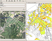
By computerizing agricultural land (farm) registers and linking them to a geographical information system (GIS), the agricultural land management system achieves efficient and effective central management of agriculture data in a visually easy-to-understand format. The system enables you to search for agricultural land parcels from both the register and the map, and also to create various types of drawings, such as distribution maps, and display attribute data according to your desired settings. Of course, the system complies with all related laws and regulations, various types of frameworks, and rules. Data linkage (sharing and distribution of intra-agency data) with the Basic Resident Register and fixed property registers is also possible, in order to achieve an integrated GIS.
- [System construction utilizing existing data] By linking to a geographical information system (GIS) based on digitized agricultural land (farm) registers, land registers, and land parcel numbers, the system can express agriculture data in a visually easy-to-understand format.
- [Providing functions ideal for agricultural land policies] The system provides efficient and effective centralized management to assist with managing rice field data, identifying idle farmland, training farmhands, and promoting measures for improving agricultural management foundation, etc.
- [Easy-to-use user interface] You can register frequently used menu items in toolbars and check all graphics and attributes in a single window.
- [Extensive map data retrieval functions] The system comes with extensive map data retrieval functions, including graphic index search, drawing number search, facility number search, ZIP code search, target object search (allows the user to add or update the target object), and address search (to access city district reference data, housing map data, etc. provided by the Geospatial Information Authority of Japan).
- [Farm register system] The system can be linked to farm registers created by multiple makers, allowing effective utilization of existing system assets.