Home>News Releases : Surface deformation accompanying the eruption of Mount Nyiragongo (DR Congo) mapped using satellite SAR analysis

June 8, 2021
Kokusai Kogyo Co., Ltd.
Kokusai Kogyo has mapped the land deformation caused by the volcanic activity of Mount Nyiragongo in the Democratic Republic of Congo (DR Congo) via ground deformation analysis using satellite-based Synthetic Aperture Radar (SAR)1 data.
1 Synthetic Aperture Radar (SAR) technology illuminates the target with microwaves and generates a ground image using the strength and phase of reflected waves.
Mount Nyiragongo is an active volcano in Eastern DR Congo, with previous major eruptions recorded in 1975 and 2002; a recent and major eruption was recorded on May 22, 2021. Mount Nyiragongo is one of the many active volcanoes associated with the African Great Rift, a series of geological trenches 35 to 100 km wide, running 7,000 km north-south in Eastern Africa, splitting the African Plate and creating new plate boundaries.
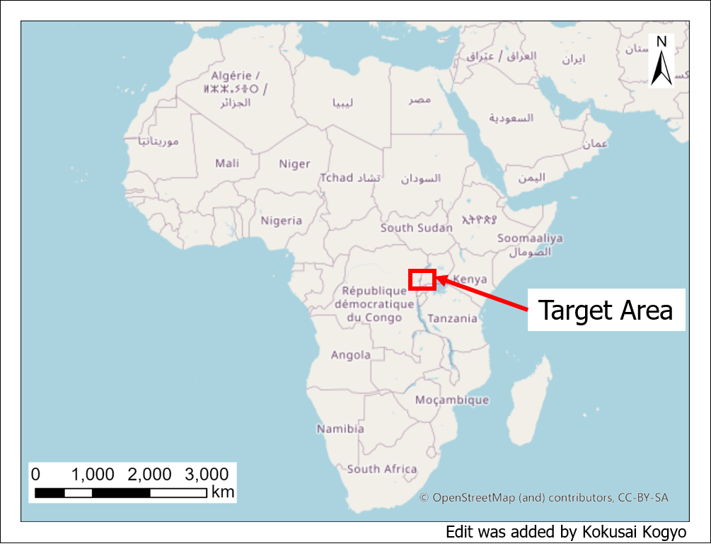
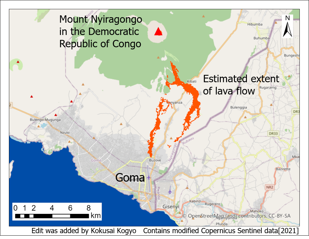
Target area of SAR-based deformation analysis Location of Mount Nyiragongo
The mapping was conducted using Kokusai Kogyo’s Multi-Monitoring Service, a tool to address climate and disaster challenges through multiple cutting-edge technologies including GPS/GNSS positioning, aerial laser survey, fixed point camera image analysis, SAR, and the use of AI. The amount of wide-area tectonic deformation accompanying the recent May volcanic eruption was analyzed through interferometric SAR analysis using satellite-based Sentinel-1 SAR data from before and after the eruption, provided by the European Space Agency.
There is growing interest in the effect of dynamic events in the most active areas of Earth, such as the African Great Rift, on the global environment. Kokusai Kogyo aims to contribute to the realization of a sustainable global future via our core competency, geospatial information.
Technical summary:
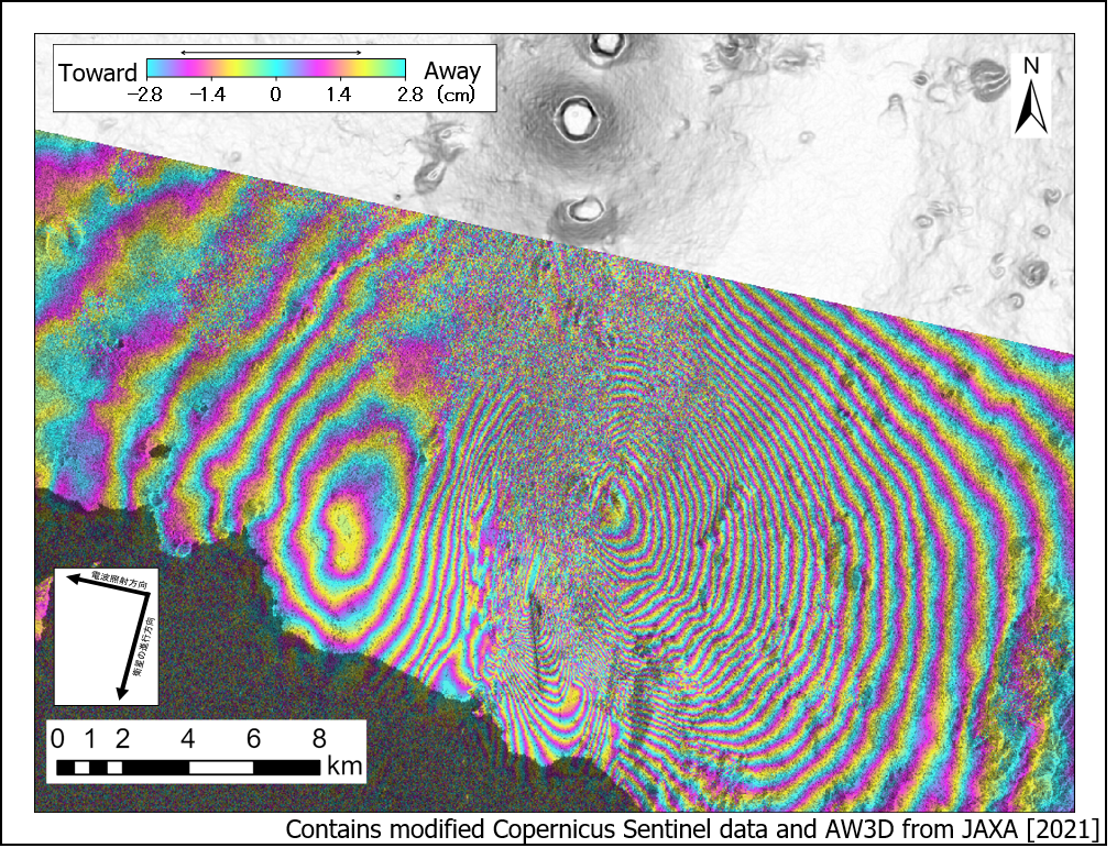
The two figures below show interferometric SAR analysis based on Sentinel-1 data from ascending and descending orbits, recorded before and after the eruption. In both figures, two concentric patterns are seen to the east and west of Goma, located approximately 10 km from the volcanic crater of Mount Nyiragongo.
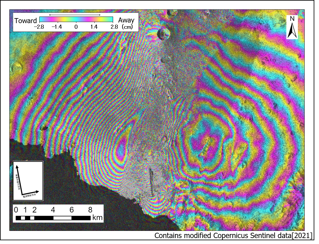
Interferometric SAR analysis: Interferometric SAR analysis:
deformation detected in ascending orbit deformation detected in descending orbit
Sentinel-1 2021/5/19 18:20 and Sentinel-1 2021/5/25 18:20 Sentinel-1 2021/5/21 5:44 and Sentinel-1 2021/5/27 5:44
Data from ascending orbits, recorded when satellites are moving south to north, can be used to detect ground that moved away from the satellite in the eastern direction and moved towards the satellite in the western direction. Data from descending orbits can be used to detect movement in the opposite direction. A full rainbow indicates 2.8 cm of deformation, and tighter concentric circles indicate higher levels of deformation.
Information from both orbits can be combined via a 2.5D surface deformation analysis2 to estimate quasi-east-west and quasi-vertical displacements.
The results of the 2.5D analysis, shown in two figures below, indicate the ground surface has moved away from Goma, towards the east and west, accompanied by uplift in the east and west and subsidence in the middle.
2 2.5D surface deformation analysis is a method to estimate the amount of deformation in east-west and vertical directions, based on SAR data from different orbits
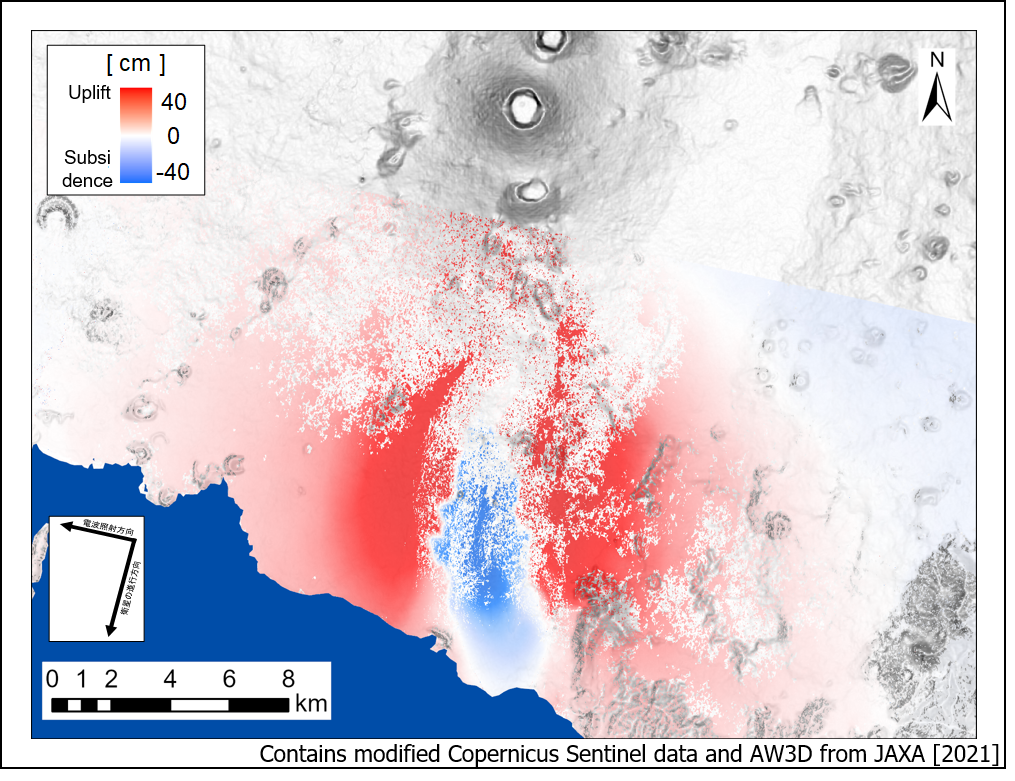
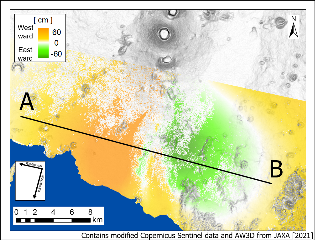
2.5D surface deformation analysis: 2.5D surface deformation analysis:
amount of deformation along vertical axis amount of deformation along east-west axis
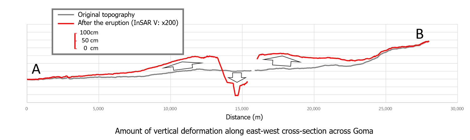
The amount of displacement in the vertical direction for cross-section A-B is further visualized in a third figure, below.
The SAR-based analysis method used to analyze and map the amount of deformation accompanying the eruption of Mount Nyiragongo is also effective in monitoring any changes over time to permanent structures such as dams, as well as event-based preventive monitoring, such as during the construction of tunnels, and is one of the tools included in Kokusai Kogyo’s Multi-Monitoring Service.
Kokusai Kogyo’s Multi-Monitoring Service is an efficient and highly sensitive monitoring solution that can be deployed in a pinpoint manner targeting specific structures and construction zones, as well as across wide areas to monitor subsidence and volcanic activity. The service is built on Kokusai Kogyo’s geospatial centric solutions and advanced analytic expertise, as well as an extensive in-house knowledge base built by expert consultants in the fields of national land development, environmental management, disaster risk reduction, and infrastructure management and maintenance.
Kokusai Kogyo Co., Ltd. /english/
![]()
Copyright © Kokusai Kogyo Co., Ltd. All Rights Reserved.