Base technologies
Capturing Data from Space
Aerial photography survey and mapping
Kokusai Kogyo began as an aerial photography survey and mapping company. Over the 60 years since then, we have utilized airplane-mounted cameras to provide the geographic data of the land as spatial information. In the beginning, images were captured on film and printed as film-based monochrome photographs, which were later changed to color photographs. Spatial data was initially provided on a paper medium, but more recently is provided as high-resolution aerial photography captured with digital cameras.
Utilizing this leading-edge technology, along with our fully digital production system, Kokusai Kogyo can provide customers with high-quality spatial data based on product specifications that comply with the Japanese Standards for Geographic Information.
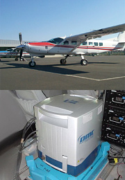
- Kokusai Kogyo was the first company in Japan to bring in the leading-edge, digital aerial survey and mapping camera, the Digital Mapping Camera (DMC) made by Z/I Imaging Corporation) and is now providing high-resolution digital aerial photography data with a ground resolution of around 5 cm.
- The DMC is equipped with a position and orientation system (POS) that simultaneously measures the three-dimensional central coordinates of the aerial photography data and their slopes, significantly reducing the geometrical correction normally required in aerial photography surveys and mapping. The DMC also has a near-infrared sensor, providing remote sensing capability that can support forest mensuration, for example.
- We create spatial data based on product specifications that comply with the Public Survey Work Rules and Regulations and the standards for geographic information. We also help create individual product specifications tailored to customer situations.
- With the introduction of the DMC, coupled with the fully digital production system we have built, we can maintain logically and visually superior quality when preparing spatial data, while shortening the delivery time.
![]()
Airborne Laser Scanning
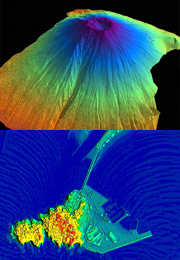
Airborne Laser Scanning is a 3D survey technology that uses an airplane-mounted laser scanner. In a laser scanning survey, a laser beam is radially emitted from an airplane toward the ground, and the geography is measured based on the time differences in the laser beams reflected from the ground. The airplane is equipped with a GPS and an IMU (gyro). By continuously obtaining the accurate position of the airplane and analyzing it along with the distance data, the X, Y, and Z values on the ground surface can be directly measured for each pulse.
With our latest 3D surveying technology, Kokusai Kogyo is providing its customers with base data that can be used for facility management, disaster prevention, and environmental preservation.
- We use sorting and extraction technologies to filter the collected data, processing it into the final data according to purpose. Utilizing a function that effectively separates structures such as buildings and trees from the ground surface, we perform the structuring task for classifying the data into the ground surface, structures, and vegetation.
- We create a digital elevation model (DEM) from the survey data and import it into a 3D CAD/GIS system, enabling its use as the base data for facility management, disaster prevention, and environmental preservation.
- Creation of a detailed 3D model of the land improves disaster-forecasting accuracy, making it useful for effective land preservation policies.
- It is expected that Airborne Laser Scanner data will be utilized in the future for a wider range of applications, such as assessment of river bed fluctuations, snow accumulation surveys, and sand movement monitoring during landslides.
- We are collecting and archiving 3D land data in a library.
- In one noteworthy application, highly precise 3D models of cities created from collected 3D data are being used to explain city-planning information to residents.