
Base technologies
Analyzing Rivers and Coasts
Tsunami and Storm Surge Simulation
There is increasing concern that, as population and assets have become more concentrated in urban areas, transportation speed and volume have increased, and social changes such as aging of the population have progressed, the extent of damage that could occur in the event of any major disaster will be very great. Kokusai Kogyo is leveraging its spatial information survey/analysis technologies to help protect life and assets against tsunamis and storm surges.
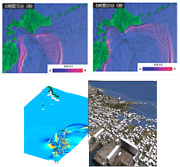
- Utilizing our expertise in creating detailed topographical models, we can simulate how a tsunami will be propagated and accurately simulate a tsunami inundation scenario by taking factors such as levees and earthen berms into consideration.
- Based on simulation results, we can create computer graphics of tsunami propagation, upland movements, and inundation; flooding damage forecasts that will be useful in reducing tsunami damage; and tsunami hazard maps, in order to communicate the danger of a tsunami to the general public in an easy-to-understand way.
![]()
Water Flow Analysis
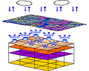
Before river alteration, erosion control, and agriculture and forestry operations can be undertaken in areas that include a river, it is necessary to create a distributed river discharge estimation model that includes the river discharge at a given spot, the groundwater level, and the soil water content, all of which are important factors comprising the land base.
A distributed river discharge estimation model is the most powerful tool for computing the river discharge at a given spot, the groundwater level, and the soil water content, etc. Kokusai Kogyo’s distributed river discharge estimation model takes land use, vegetation, soil, and geology into consideration, resulting in the creation of extremely practical, high-precision models with a high level of reproducibility.
- We can accurately estimate the hydrological conditions at any spot in the land space.
- We provide both radar precipitation estimates and ground-level precipitation estimates.
- Our data can be used for modeling floods, droughts, and slope ruptures, as well as for their validation.
- We can create a real-time system for forecasting floods, droughts, and slope ruptures.
![]()
Shore Change Analysis
Many of the sand beaches of Japan have been, in recent years, in the midst of rapid change, and a number of risks due to shore erosion have become apparent in areas across Japan, such as increased wave-related disaster prevention risks, deteriorating coastal environments, the loss of usable coastal space, and the like. The causes of coastal erosion, and actual erosion conditions, vary greatly from place to place, and in many places, there are multiple factors behind erosion. Correctly analyzing those causes and conditions is vitally important.
At Kokusai Kogyo, teams of specialized technicians use spatial data measurement and analysis technologies, and their own advanced knowledge and experience, to diagnose the health and symptoms of coastal areas, contributing to the protection of coasts.
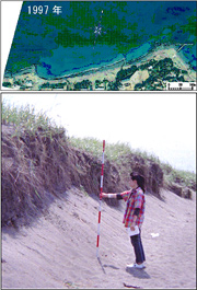
- Chronological ranges of aerial photographs and detailed terrain data can be used to analyze coastal landform changes, and analysis results provided to coastal landform change simulations, to create scientifically-based cause analyses, future landform predictions, and the like.
- In order to make use of cutting-edge knowledge and analysis evaluation techniques, a cooperative structure which incorporates specialists (academics) in individual fields is always in place, ready to resolve a wide range of problems.
- Changes such as beaches becoming smaller than they once were, slopes becoming more pronounced, the appearance of beach scarps, and sand grains becoming rougher are all important signs of beach condition changes. In order to avoid missing these signs, specialists are sent on-site to perform observation. Information obtained from local residents can also provide important leads, so we provide our know-how in workshop and resident consensus formation meeting operation and the like as well.