
Base technologies
Analyzing the Environment
Analysis of Water Quality in Closed Bodies of Water
In rivers and closed bodies of waters such as lakes, ponds, and dam-created reservoirs, point source countermeasures, such as building sewage infrastructure and regulating the discharge from factories and business operations, have been implemented in order to preserve water quality. More recently, it has become more urgent to also address non-point pollution sources such as agricultural land, urban areas, and mountains and forests.
To develop optimum water quality preservation measures that suit the characteristics of each watershed, it is important to assess the pollution load in the watershed based on the latest data, analyze the water circulation and load circulation in the watershed, and also to accurately forecast and evaluate the changes in water quality that will occur in closed bodies of water after various measures are implemented.
Kokusai Kogyo assists in the creation of water quality preservation plans and their implementation, by organically linking a watershed information database with a water circulation model, a load circulation model, and a water quality forecasting model for closed bodies of water.
- By assessing land use from data provided by remote sensors, we provide highly precise analyses.
- By conducting a unit requirement survey tailored to an individual watershed to determine its unique unit requirement, we provide a highly precise non-point source load estimate.
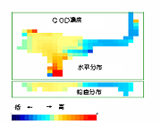
- Using our numeric models, which have been proven effective all over the country, we provide realistic water quality projections that include the movements of zooplanktons and phytoplanktons, for closed bodies of water.
- We present the projection results in an easy-to-understand visual format.
![]()
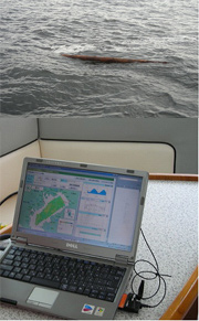
Marine Radar Seaborne Garbage Distribution and Movement Forecasting System
There is a growing problem of vegetation, household garbage, oil runoff, and other contaminants being carried by rivers into closed bays, polluting the surface, as well as large floating garbage, including driftwood, causing an impediment to ship navigation. In order to eliminate this, the Ministry of Land, Infrastructure, Transport and Tourism Ports and Harbours Bureau carries out marine environment maintenance operations, using marine environmental improvement ships which collect floating garbage and oil runoff.
Kokusai Kogyo creates not only systems which display and distribute marine phenomena information based on marine radar, but also a large number of systems which track current rip positions and floating garbage positions based on sea surface current determined via marine radar, estimating current and future garbage distributions, leading to improved marine environment improvement ship efficiency.
It is expected that these technologies will be utilized to tackle the problem of garbage drift from the mainland, which has become a major problem in recent years, by determining garbage routes, forecasting float times / locations, and more.
- Multiple users can use systems simultaneously due to their Internet-based client server architecture.
- Marine garbage accumulation current rip position forecasting and discovered garbage movement position forecasting can be performed.
- Weather and hydrological data can be automatically acquired, and river garbage effluence forecasts made.
- Actual marine garbage collection information (date/time, location, amount, type) can be converted into database form for statistical analysis.