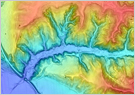
- Topographic Contour Analysis (Elsa Map)
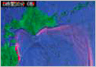
- Image Decipherment Investigation (Aerial Photograph Decipherment, Numerical Terrain Data Image Decipherment)
- Ground Surface Characteristics Analysis (Assessment of Landslide Distribution)
- Land Deformation Analysiss (Assessment of Sand Movement Volume and Ground Surface Movements)
- GPS-based displacement monitoring
- Underground Geology Analysis
- Disaster Prone Location Evaluation
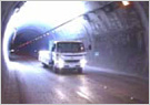
- Snow Accumulation Condition Analysis
- Soil Movement Simulation (Sand and Stone Avalanches, Lava Flows, etc.)
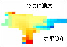
- Volcanic Ash Movement Simulation
Base technologies
Analyzing Land Contour