
International Consulting
Disaster Risk Reduction
Mauritius
| Title | : | The Project of Landslide Management |
| Period | : | March 2012 – September 2014 |
| Funded by | : | JICA |
Mauritius is particularly vulnerable to climate change and has an increasingly serious problem with landslides caused by natural disasters, environmental changes and an increase of tourism-related structures and land development on steep slopes.
Against this background, various climate change adaptation programs are being conducted in Mauritius mainly by the Japanese Government and the Africa Adaptation Programme (APP) under the United Nations Development Programme (UNDP), including this project.
It is closely tied to another project by Kokusai Kogyo experts to assist Mauritius in developing capacity in coastal protection and rehabilitation, which is also related to APP.
This coastal protection project involves five components:
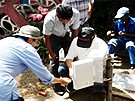
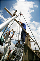
- 1. Development of a landslide database by collecting and putting in order existing data, and when deemed necessary, to conduct field surveys, geophysical exploration, test drilling and aerial photo interpretation and to make topographic and geological maps.
- 2. Formulation of a landslide management plan to establish a landslide monitoring system.
- 3. Implementation of a feasibility study and pilot project to examine, carry out and learn specific approaches.
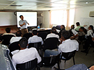
- 4. Enhancement of the technical capacity of staff in Ministry of Public Infrastructure (MPI) and other administrations.
- 5. Implementation of pilot projects focusing heavily on public participation and involvement of relevant agencies; the results of which are to be reflected in the landslide management plan.
Ethiopia
| Title | : | Project for Developing Countermeasures against Landslides in the Abay River Gorge / Capacity Development Project for Countermeasure Works for Landslides in Ethiopia |
| Period | : | April 2010 – December 2011 , June 2011 – March 2016 |
| Funded by | : | JICA |
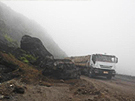
Ethiopia’s Route 3 is vital to its economy as it runs through Amhara Regional State, an important granary of the country, and is also used for transporting crude oil from Sudan.
On the 40-km section of Route 3 passing through the Abay River Gorge, however, landslides are common during the rainy season and appropriate countermeasures based on an understanding of the complex landslide mechanisms are urgently needed. The Ministry of Mining and Energy established a department of Geo-hazard Investigation within the Geological Survey of Ethiopia (GSE) in 2009 as a special body to investigate landslides, but its capacity is still limited.
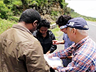
The first project that started in 2010 aimed to figure out the mechanisms of landslides and to upgrade the technical capability of GSE in landslide investigation and analysis. Kokusai Kogyo’s consultants, together with GSE officers, carried out in-depth field surveys, analyzed a range of data collected, and defined the causes and stability of landslides.
In the subsequent technical cooperation project, started in 2011, we will implement physical and institutional countermeasures against landslides in cooperation with Ethiopian Roads Authority (ERA). The project activities include organizational strengthening of ERA, implementation of emergency countermeasure works, preparation of a landslide handbook and other materials and landslide monitoring to maintain the road condition.
Uzbekistan
| Title | : | The Project on Capacity Development for Landslide Monitoring |
| Period | : | October 2007 – September 2010 |
| Funded by | : | JICA |
Uzbekistan is 20% mountainous (90,000 km2), of which between 15,000 and 17,000 km2 is subject to landslide disaster risk. The landslide area includes more than 500 villages where from 100 to 300 landslides occur every year, particularly in the thawing season. To mitigate the enormous negative impact, both social and economic, of landslide disasters, the government of Uzbekistan established the State Monitoring Service (SMS) for Hazardous Geological Process to monitor geological hazards, which currently monitors 500 landslide sections in the country.
However, the lack of technical capability in the analysis of mass movement and management of risk stands in the way of taking the necessary actions on up-to-date and suitable countermeasures.
Under these circumstances, Kokusai Kogyo’s engineers were dispatched and first procured boring machines, extensometers, borehole inclinometers, alarming devices for extensometers, electric explorers, groundwater level meters and others.
Using such equipment and assistance of our engineers, counterparts of SMS and Hydroengeo (Institute of Hydrology and Geological Engineering, the supporting body of SMS) were provided with training of boring, methodology of installation, measurement and maintenance of various monitoring equipment, and analytical skills of mass movements. We also successfully hosted an international seminar on landslide monitoring with nearly 100 participants from seven countries other than Uzbekistan and Japan, and promoted multi-national networking for further cooperation.
Japan
| Title | : | Study for Emergency Response Preparedness in Case of an Epicentral Earthquake in the Tokyo Metropolitan Area |
| Period | : | October 2005 – March 2006 |
| Funded by | : | JICA |
This study is to facilitate the emergency preparedness of JICA offices in the Tokyo Metropolitan Area and Yokohama area assuming an epicentral earthquake were to occur in the Tokyo Metropolitan Area in order to secure the safety of its staff and visitors, maintain its fundamental functions, and, if affected, restore its business as soon as possible.
Based on the study result of JICA’s roles, human resources allocation, and existing facilities and its related organizations, Kokusai Kogyo analyzed the degree of impact an epicentral earthquake would have on JICA and investigated preventive measures and emergency response actions.
Finally, we prepared two types of emergency response manuals: one to be followed by all JICA staff and another specifically for the executive officers and those who would be stationed at the emergency headquarters. Furthermore, we proposed a disaster drill plan and a business continuity plan (BCP).
The Cabinet Office and Ministry of Economy, Trade and Industry has been encouraging organizations to prepare a BCP, but there are still few BCPs in the public sector so this one served as a precedent.
With our valuable experience in disaster management in Japan and a practical understanding of JICA’s business functions through overseas consulting services in the past, our output was appreciated for its comprehensiveness and practicability.
Guatemala
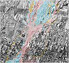 Flood Hazard Map (Samala River, Guatemala)
| Title | : | The Study for Establishment of Base Maps and Hazard Maps for GIS |
| Period | : | January 2001 – September 2003 |
| Funded by | : | JICA |
In 1996, the government of Guatemala signed a peace agreement under the supervision of the United Nations, putting an end to its 36-year civil war—the longest running conflict in Central America. The Guatemalan government has been faced with issues essential to carry out the peace agreement such as securing land for the resettlement of refugees, establishing infrastructure and so on.
Meanwhile, the country is vulnerable to various natural disasters including volcanic eruptions and earthquakes. In this study, we established base maps and hazard maps (orthophoto maps for earthquakes, volcanic eruptions, landslides, and floods) for GIS in order to promote sound national recovery.
Technical transfer included not only the on-the-job training for the development and maintenance of such a GIS database, but also seminars and workshops on disaster preparedness.
Sort by region
| Geospatial Information | Forestry | Disaster Risk Reduction | Energy |
| Water and Sanitation | Agriculture | Urban Development | Others |
Sort by sector
| Asia | Middle East | Europe | Africa |
| South and Central America | Oceania | Worldwide |