
Climate change countermeasures
River data management
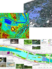
Governmental policy on rivers must be based on a comprehensive approach that addresses environmental issues in addition to flood control and water utilization. To develop such a plan, it is essential to manage the wide variety of data related to rivers and their surrounding area. Leveraging the advanced spatial information technologies it has nurtured over many years, Kokusai Kogyo can help with the creation and execution of sound riverine plans by preparing, utilizing, and providing the necessary spatial data.
- We develop the core data by adding 3D topographical data taken from both topographic and urban models, as well as image data such as satellite images, to a 2D riverine GIS that provides the base data.
- In compliance with the ISO/TC211, the global geographical data standard, we help create a framework for sharing and utilizing data, that includes standardization of the spatial information necessary for the government’s riverine policies and search, acquisition, and delivery of data through a clearinghouse.
- We provide a wide variety of visual data uniquely suited to individual applications, including flood zone maps, hazard maps, water circulation simulation, water supply and discharge system management, riverine environment data diagrams, comprehensive learning, environmental learning, and archival content.