
Geospatial × ICT
3D geospatial data service RAMSE-e
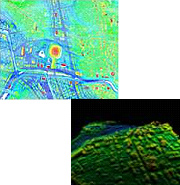
RAMS-e is our proprietary service for the provision of highly accurate airborne laser scanning data.
Airborne laser scanning is a technique of surveying the earth’s topography by calculating the time elapsed from emission of a laser beam from an aircraft until the beam is subsequently reflected of the ground surface and reaches the aircraft again.
This allows the rapid acquisition of high precision and high resolution three-dimensional spatial data.
- We have Japan’s most extensive private laser scan data archives. We are able to provide data much cheaper and faster than surveys to order because we sell laser scan data that we have already been surveyed.
-
We have classed our data into three levels according to intended use.
-Level 1: Original survey data acquired by airborne laser profiler
-Level 2: Level 1 data processed into two-meter grid data
-Level 3: Level 1 data that has undergone electronic filtering (to remove objects such as vegetation and buildings), in the form of two-meter grid elevation data