Geospatial × ICT
High-definition aerial photography
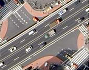
Kokusai Kogyo’s high-definition aerial orthophotos are made from ultra-high resolution aerial photo data taken with an approximately 100 million pixel aircraft-mounted digital camera specially developed for aerial surveying. These are used for a multitude of purposes by our clientele, from accurately grasping the situation in remote locations for planning purposes to content for 3D urban models and background imagery for promotional material.
- We provide data at three resolution levels, 10 cm, 25 cm and 50 cm so as to fit a range of end uses.
- Our high-definition aerial photos are accurately corrected for distortions and inclination using the aircraft’s position and orientation system (POS) that is interlinked with the digital aerial camera to give highly precise position and orientation data for every photo.
- Our clients can instantly access our extensive archives of high-definition aerial orthophotos from all over Japan. We also respond to our client’s every need with surveys to order.