
Geospatial × ICT
Water supply data management system
Our water supply facility data management system (Seseragi) is a package software program designed to improve the efficiency and sophistication of water supply facility management operations, by properly managing and utilizing the massive amounts of data and information surrounding water service operations. Our system delivers a large amount of spatial data at high speeds and is user-friendly, even for employees who are not familiar with its operations.
The wide variety of functions included in addition to the system’s viewing and printing functions, provide operational support and help improve the efficiency of creating various types of reports.
Furthermore, you can choose to use an individual (C/S) GIS-type system having specialized functions, a WebGIS-type system that can be used by many employees at low cost, or both in combination.
- [Acceleration and efficiency improvement in data search operations]
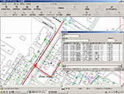
Our system makes it easy to search for various types of data, such as pipe attributes, completed piping maps, the scope of water service disruption during a pipe accident, and user-related data. - [Easy-to-use user interface]
You can register frequently used menu items in toolbars and check all graphics and attributes in a single window. - [Extensive map data retrieval functions]
Our system comes with extensive map data retrieval functions, including graphic index search, drawing number search, facility number search, ZIP code search, target object search (allows the user to add or update the target object), and address search (to access city district reference data, housing map data, etc. provided by the Geospatial Information Authority of Japan). - [Map management streamlining]
Once the system is activated, you can directly check facility locations and data. In addition, electronic delivery of project completion maps results in further reduction in the number of paper maps. - [More advanced operations]
Our system improves the sophistication level of operations through the use of operation-support functions, such as those that help with water service disruption planning and pipe installation planning. Our system also utilizes data in a sophisticated manner to perform analyses that have been extremely difficult to carry out using conventional paper maps. For example, it can accumulate leakage survey results and associate types of pipes with the years in which they were installed. - [Emergency support]
Our system allows successive registration of damage status data during an emergency such as an earthquake, making it available for providing information quickly, planning emergency water supply locations and supply methods, and selecting emergency recovery routes.